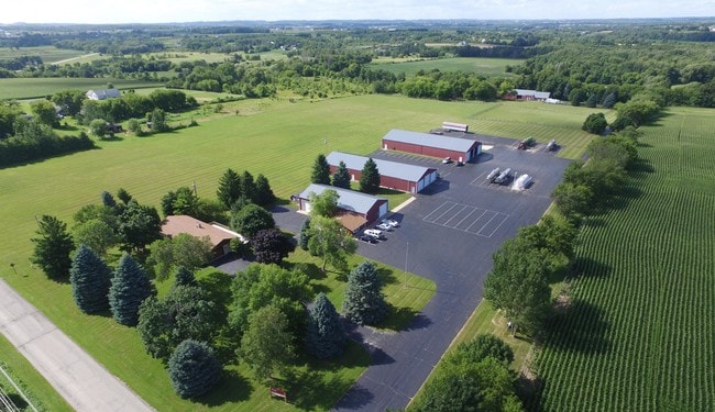
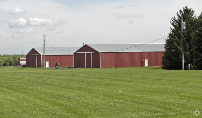
Property Record
Cedar Ln, Richfield, WI 53076
NEARBY LISTINGS FOR SALE OR LEASE
Property Detail
Cedar Ln
T5-0141
PT E1/2 SE NW V817 P308+V980 P222+V1370 P109 DOC 905339+1169503+1572804+1576125 EXC PT SOLD
Agriculturalland
Washington
X
Wisconsin
55131C0269E
7.52 AC
2024
Washington East
2024
Milwaukee/Madison
460101
Milwaukee-Waukesha, WI
DEMOGRAPHICS near Cedar Ln
1 Mile
3 Mile
5 Mile
2024 Total Population
372
6,824
27,332
2029 Population
371
6,772
27,076
Pop Growth 2024-2029
(0.27%)
(0.76%)
(0.94%)
Average Age
42
44
43
2024 Total Households
142
2,706
11,311
HH Growth 2024-2029
(0.70%)
(0.81%)
(1.12%)
Median Household Inc
$104,500
$99,156
$90,965
Avg Household Size
2.60
2.50
2.40
2024 Avg HH Vehicles
2.00
2.00
2.00
Median Home Value
$363,095
$338,524
$310,114
Median Year Built
1972
1985
1986
Nearby Places
Map Layers
Map Styles
 Street
 Aerial
- Restaurants
- Banks
- Shops
- Fitness
- Groceries
PUBLIC TRANSPORTATION
AIRPORT
General Mitchell International
DRIVE
WALK
Distance
General Mitchell International
51 min
35.5 mi
Freight Ports
Port Milwaukee
DRIVE
WALK
Distance
Port Milwaukee
45 min
31.7 mi
Nearby Properties
Address
Land Use
TOTAL SIZE
Lot Size
Zoning
Address
Land Use
TOTAL SIZE
Lot Size
Zoning
706,000 SF
39.22 AC
Address
Land Use
TOTAL SIZE
Lot Size
Zoning
Address
Land Use
TOTAL SIZE
Lot Size
Zoning
240,468 SF
20.03 AC
Address
Land Use
TOTAL SIZE
Lot Size
Zoning
233,282 SF
17.13 AC
Address
Land Use
TOTAL SIZE
Lot Size
Zoning
32.89 AC
Address
Land Use
TOTAL SIZE
Lot Size
Zoning
Address
Land Use
TOTAL SIZE
Lot Size
Zoning
203,580 SF
13.52 AC
Address
Land Use
TOTAL SIZE
Lot Size
Zoning
204,373 SF
16.50 AC
Address
Land Use
TOTAL SIZE
Lot Size
Zoning
198,648 SF
16.57 AC
Address
Land Use
TOTAL SIZE
Lot Size
Zoning
104.57 AC
Address
Land Use
TOTAL SIZE
Lot Size
Zoning
146,022 SF
8.51 AC
Address
Land Use
TOTAL SIZE
Lot Size
Zoning
Address
Land Use
TOTAL SIZE
Lot Size
Zoning
130,000 SF
12.76 AC
Address
Land Use
TOTAL SIZE
Lot Size
Zoning
99,710 SF
9.55 AC
Address
Land Use
TOTAL SIZE
Lot Size
Zoning
28,840 SF
12.02 AC
Address
Land Use
TOTAL SIZE
Lot Size
Zoning
100,000 SF
13.07 AC
Address
Land Use
TOTAL SIZE
Lot Size
Zoning
10.93 AC
Address
Land Use
TOTAL SIZE
Lot Size
Zoning
12,000 SF
5.96 AC
Address
Land Use
TOTAL SIZE
Lot Size
Zoning
67,200 SF
5.90 AC
Address
Land Use
TOTAL SIZE
Lot Size
Zoning
6,664 SF
9 AC
Address
Land Use
TOTAL SIZE
Lot Size
Zoning
Address
Land Use
TOTAL SIZE
Lot Size
Zoning
5.35 AC
Address
Land Use
TOTAL SIZE
Lot Size
Zoning
Address
Land Use
TOTAL SIZE
Lot Size
Zoning
10.32 AC
Address
Land Use
TOTAL SIZE
Lot Size
Zoning
18.39 AC
Address
Land Use
TOTAL SIZE
Lot Size
Zoning
Address
Land Use
TOTAL SIZE
Lot Size
Zoning
Address
Land Use
TOTAL SIZE
Lot Size
Zoning
51,730 SF
5.52 AC
Address
Land Use
TOTAL SIZE
Lot Size
Zoning
13.89 AC
Address
Land Use
TOTAL SIZE
Lot Size
Zoning
The World's #1 Commercial Real Estate Marketplace
Connect with us
© 2026 CoStar Group
The information above has been obtained from sources believed reliable. While we do not doubt its accuracy we have not verified it and make no guarantee, warranty or representation about it. It is your responsibility to independently confirm its accuracy and completeness. Any projections, opinions, assumptions, or estimates used are for example only and do not represent the current or future performance of the property. The value of this transaction to you depends on tax and other factors which should be evaluated by your tax, financial, and legal advisors. You and your advisors should conduct a careful, independent investigation of the property to determine to your satisfaction the suitability of the property for your needs.